Nasa Logo


+ Home
Solar Physics
       + Solar Cycle Prediction         + Magnetograph       + The Sun in Time       + The Hinode Mission      + The STEREO Mission
Skip Navigation Links

THE SUN  

Why We Study the Sun  
The Big Questions  
Magnetism - The Key  

SOLAR STRUCTURE  

The Interior  
The Photosphere  
The Chromosphere  
The Transition Region  
The Corona  
The Solar Wind  
The Heliosphere  

SOLAR FEATURES  

Photospheric Features  
Chromospheric Features  
Coronal Features  
Solar Wind Features  

THE SUN IN ACTION  

The Sunspot Cycle  
Solar Flares  
Post Flare Loops  
Coronal Mass Ejections  
Surface and Interior Flows
Helioseismology  

THE MSFC SOLAR GROUP  

The People  
Their Papers  
Their Presentations  

RESEARCH AREAS  

Flare Mechanisms  
3D Magnetic Fields  
The Solar Dynamo  
Solar Cycle Prediction  
Sunspot Database  
Coronal Heating  
Solar Wind Dynamics  

PREVIOUS PROJECTS  

GOES SXI Instrument
MSFC Magnetograph  
MSSTA
Orbiting Solar Obs.
Skylab
Solar Maximum Mission
SpaceLab 2
TRACE
Ulysses
Yohkoh

SOUNDING ROCKETS  

Chromospheric Lyman-Alpha Spectro Polarimeter (CLASP)
CLASP2
CLASP2.1
Marshall Grazing Incidence X-ray Spectrometer (MaGIXS)

CURRENT PROJECTS  

GONG
Hinode
RHESSI
STEREO
SDO
SOHO

OUTREACH  

The Sun in Time  
Solar Information for Teachers  
Eclipses and the Sun -- Girl Scouts

FUTURE PROJECTS  

Solar Probe Plus  
Interstellar Probe

VIDEOS  

NASA Videos

Solar Magnetic Field Evolution


Animated Magnetic Maps

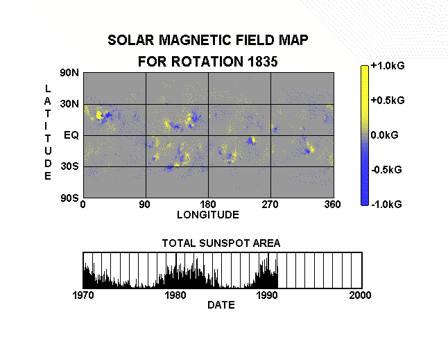
The Sun's magnetic field is the source of most (if not all) solar activity. The strength of the magnetic field is determined by variations in the polarization of light from different chemical elements in the Sun's atmosphere. As the Sun rotates once in about a month, observations of the Sun's magnetic field are combined to construct maps of the magnetic field at the Sun's surface.

Maps from the National Solar Observatory for the previous 6 years are animated here to show the evolution of these magnetic field patterns. Yellow represents field coming "out" of the Sun (positive or North polarity) and blue represents field going "into" the Sun (negative or South polarity). The strip along the bottom indicates the date the map was taken by plotting the solar sunspot cycle up to that particular rotation of the Sun.

This animation shows how active regions, places where magnetic fields erupt through the Sun's surface, decay as the field elements spread out across the surface. It shows that the latitude where activity occurs moves toward the Sun's equator as the sunspot cycle declines. Careful inspection also reveals differential rotation - regions near the equator drift to the right while regions above 30 degrees latitude drift to the left - and meridional flow - magnetic elements drift away from the equator and toward the poles.

A 12.8 Mb Quicktime movie covering 20 years of the Sun's magnetic history is available here. A 2.3 Mb MPEG movie is avaliable here. A 138 Mb AVI movie covering 1976 through 2005 is available (for those with patience and/or high bandwidth) here.


Web Links
NOAA's Space Weather Prediction Center - Today's Space Weather Updated Every 5-minutes
NOAA's Solar Data Services - Includes Irradiance, Emissions, Sunspot Data (also Ancient), Flares, Corona, and Plage
SDO Data - Latest Images from the Solar Dynamics Observatory
National Space Weather Program - The U.S. Government and Space Weather
High-Energy Astrophysics - MSFC's Imaging X-Ray Polarimetry Explorer (IXPE)
First Gov Image + NASA Privacy Policy and Important Notices
+ Visit Solar Terrestrial Probes Program
+ Visit Living With a Star Program
NASA Logo Image Author: Dr. David H. Hathaway, dave.hathaway @ comcast.net
Curator: Mitzi Adams, mitzi.adams @ nasa.gov
NASA Official: Dr. David McKenzie david.e.mckenzie @ nasa.gov
Last Updated: September 22, 2022